INDEPENDENT CONTRACTOR
WORK EXPERIENCE
GEOSPATIAL TRAINING SERVICES

2017 - CURRENT
-
ARCGIS ONLINE COURSE CREATION
-
Create course content and materials related to ArcGIS Online solutions
-
Provide presentation and exercise materials
-
Live-online and in-person instruction of courses
-
-
SPECIAL PROJECTS
-
Created story map tabbed series based on 37 years of wildfire data, including time animation, mega fire focus and multiple embedded Web AppBuilder applications to allow filtering of map view by specific variables (human caused, year, organization, etc.)
-
-
MARKETING
-
Developed Survey123 to help understand needs of target audience and stream results through Dashboards
-
Create outreach and advertising materials and layouts
-
Created and manage YouTube channel, develop videos and other content
-
Help maintain website
-
Social media marketing content
-
IDAHO COMMISSION ON THE ARTS

2021 - CURRENT
-
SURVEY INVENTORY FORM
-
Collaborate with a team to develop and create concepts for a survey123 inventory form
-
Assess data needs from the group and create schema that will be necessary prior to developing survey123
-
Configure survey123 using branding guidelines from the State and revise/update based on feedback from the team
-
-
INTEGROMAT AUTOMATED EMAILS
-
Configure Integromat automated emails triggered by Survey123 initial submissions and for updated submissions
-
-
CREATIVE DISTRICT DIRECTORY
-
Configure an ArcGIS Experience Builder application using branding guidelines from the State as a directory of creatives
-
Connect and stream data and images directly from Survey123 inventory form submissions
-
Utilize widgets that have interactivity and actions applied
-
-
REGULAR MAINTENANCE & UPDATES
-
Perform regular maintenance to ensure applications are running smoothly
-
Update as needed based on feedback from stakeholders
-
CASCADE RURAL FIRE DEPARTMENT

2017 - 2018, 2021
-
Create large (6'x6') wall map of Fire Protection District for navigation and training purposes, with street index
-
Organized, reconciled and updated spatial data related to structural Mobile Risk Assessment (MRA) surveys
-
Compared MRA points to County address points to find potential structures that have no MRA data
-
Provided a list of needs
-
-
Made recommendations for further steps to obtain fire department goals for streamlining and efficiency
-
Created online map application for viewing and use of data
-
Helped empower volunteer fire-fighters on basics of updating data in the online map application
-
Made recommendations on technology to aid in field-use of online the online map application
-
-
Periodically consult for free on how to process certain changes or updates
EDWARDS MOSQUITO ABATEMENT DISTRICT

2017 - CURRENT
-
STORY MAP
-
Create StoryMap to help tell the story of the district what it does and why it's important
-
Create and embed ArcGIS Online Experience of most-wanted mosquitos directory
-
Configure and embed zone lookup instant app to help community find out if they are in the district
-
Configure Survey123's for self-reporting of no-spray areas and potential mosquito infestations
-
Devise the story of the district and display it in the StoryMap based on reports, website information, research, and notes taken from meetings with the director
-
-
DISTRICT BOUNDARY RECONCILIATION
-
Look into boundary discrepancies based on Idaho State Tax Commission data and actual boundary data provided by the district
-
Help district to report and correct boundary discrepancies to the State of Idaho
-
-
ARCGIS ONLINE DATA MAINTENANCE
-
Update datasets as necessary
-
Create new datasets as necessary
-
Organize data and create meta data as necessary
-
PAYETTE NF
DISPATCH CENTER

2019 - CURRENT
-
PROJECT COORDINATION
-
Meet with wildland fire dispatchers to discuss details and needs in a basemap
-
Determine most important visuals to emphasize
-
Observe dispatchers in the use of WildCAD to understand how basemap display will function
-
Seek out appropriate datasets
-
-
CARTOGRAPHY
-
Configure a large, static layout for WildCAD dispatch system basemap to be used for dispatch and emergency response
-
Utilize cartographic principles that allow for important information to be viewed at multiple scales, with larger location principles, such as Townships and Ranges, to be viewed when zoomed at while road names and important locations be visible when zoomed in
-
-
MAINTENANCE AND UPDATES
-
Complete maintenance and updates annually based on feedback from dispatch employees and leadership
-
Seek out data and create layers of important information that can be used in tandem with the basemap within WildCAD
-
NORTHWEST CULTURAL RESOURCES

2016 - 2018
-
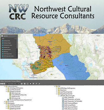
Contracted to compile data from multiple sources and formats to create spatial data for Archaeological tracing of Native American family lineages throughout a large region of California
-
Created a single map in ArcGIS Desktop
-
Created ArcGIS Online account for the client and used all associated data to produce an online map application for ease of looking up and viewing information
-
Compiled a how-to-use email/document for stakeholders involved in the project
-
Attached any related documents to records in both the desktop and online map
-
Organize and create a user-friendly and easy to manage filing system for data transfer to client
-
Included meta data tables and screenshots of filing system with format descriptions
-