GIS IN LOCAL GOVERNMENT
WORK EXPERIENCE
GIS PROGRAM COORDINATION

2017 - CURRENT
-
Collaborate across all departments to determine spatial data and GIS needs
-
Utilize ArcServer, SQL Studio, ArcGIS Desktop 10.x, ArcGIS Pro, ArcGIS Online
-
Administer ArcGIS Online groups, members, permissions, and security
-
Create and maintain GIS Portal and open data for public and internal-secure purposes
-
Create and maintain interactive map applications for public and internal-secure purposes
-
Train regularly and modernize mapping techniques and uses based on GIS advancements
-
Create and customize datasets for GIS use through queries in Microsoft SQL Server
-
Perform geospatial analysis and summary statistics as needed
-
Create cartographic products for visual aids, public meetings, official reporting, and planning
-
Develop data and databases and streamline processes to help departments maintain data
-
Make budget and purchase requests annually
ONLINE MAPS AND APPLICATIONS

2017 - CURRENT
-
Create groups, members, permissions as needed
-
Utilize ArcGIS Online Cloud solutions:
-
Web AppBuilder, Dashboards, StoryMaps, Experience Builder, Hub/Portal Sites, Collector/Field Maps, Survey123, Instant Apps
-
-
Configure dynamic reports with Geocortex Reporting Widget
-
Create and maintain all ArcGIS Online Maps and Applications for both the public and inter-departmental use
-
Determine best Online GIS solution for departments and the public based on organization and community needs
-
Utilize Web AppBuilder Developers edition for use with custom reports
-
Administer and maintain 25+ online maps and apps, 10+ mobile devices
-
Conduct online map and app training for employees and the public
911 DATA MIGRATION AND MAINTENANCE

2017 - CURRENT
-
Maintain 9-1-1 and dispatch spatial data in a timely and efficient manner
-
Create address update process that streamlined communication between multiple departments
-
Coordinate with Dispatch Supervisor to confirm data needs and ensure zone boundaries are current
-
Coordinate with Spillman GIS support to learn new systems and configure all required portals correctly
-
Create and modify datasets to meet new schema standards for migration to Spillman/Flex dispatching systems and software
-
Request and incorporate data from US Forest Service, US Geological Survey, Idaho State and other resources to provide reference data
-
Create address, street, point of interest and block locators with conventional and alternate names to allow for most flexibility when searching for a location
-
Create day and night map cartography and publish to Spillman Servers for use in both local and mobile map applications
-
Update data on a weekly basis
ASSET & DATA MANAGEMENT

2017 - CURRENT
-
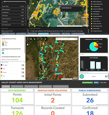
Create and maintain asset management dashboards for multiple departments through the combined use of:
-
ArcGIS Story Map Applications
-
Web AppBuilder
-
Operations Dashboard
-
Collector/Field Maps for ArcGIS
-
Survey123 for ArcGIS
-
Instant Apps
-
Field Tablets
-
Windows OS, Android, iPad
-
-
-
Consult on the best technological capabilities, software, and devices that should be used based on project and department needs
-
Maintain meta data for all critical datasets
-
Conduct offline application field training for employees
-
In-personal training, or online how-to videos and printed manuals
-